Upgrade & Secure Your Future with DevOps, SRE, DevSecOps, MLOps!
We spend hours scrolling social media and waste money on things we forget, but won’t spend 30 minutes a day earning certifications that can change our lives.
Master in DevOps, SRE, DevSecOps & MLOps by DevOps School!
Learn from Guru Rajesh Kumar and double your salary in just one year.
Introduction
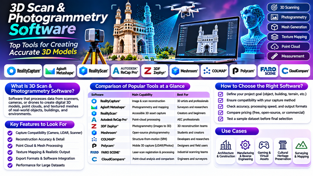
3D scan and photogrammetry software helps professionals transform real-world objects, buildings, landscapes, and environments into detailed digital 3D models. These technologies are widely used in architecture, engineering, construction, manufacturing, gaming, healthcare, cultural heritage preservation, and visual effects.
Whether you need to scan a small product, document a construction site, or recreate a historical monument, choosing the right software can improve accuracy, reduce manual work, and streamline your 3D modeling workflow.
What Is 3D Scan & Photogrammetry Software?
3D scan and photogrammetry software processes data captured using scanners, cameras, drones, or mobile devices to create digital 3D representations.
3D scanning typically uses technologies such as laser scanning, structured light, or LiDAR to capture an object’s geometry. Photogrammetry reconstructs three-dimensional shapes from multiple overlapping photographs by identifying shared features and calculating their spatial positions.
Many workflows combine both approaches to create accurate meshes, point clouds, textures, orthophotos, and other digital assets.
Top 3D Scan & Photogrammetry Software Tools
1. RealityCapture
RealityCapture is a photogrammetry solution used to reconstruct detailed 3D models from photographs and laser scans. It is popular in surveying, cultural heritage documentation, visual effects, and large-scale environment reconstruction.
Key features:
- Reconstruction from images and supported laser-scan data
- Detailed textured mesh generation
- Large dataset processing
- Measurement and georeferencing workflows
Best for: Professionals who need detailed 3D reconstruction from extensive image collections.
2. Agisoft Metashape
Agisoft Metashape processes photographs into 3D models, point clouds, digital elevation models, and orthomosaics. It supports applications in surveying, mapping, archaeology, agriculture, and research.
Key features:
- Photogrammetric 3D reconstruction
- Orthomosaic and elevation model generation
- Camera calibration and georeferencing
- Texture generation and measurement tools
Best for: Mapping, research, surveying, and professional photogrammetry projects.
3. RealityScan
RealityScan is designed to make photogrammetry more accessible, including workflows that capture real-world objects using mobile devices. It can help creators produce 3D assets for games, visualization, and digital content.
Key features:
- Image-based 3D asset capture
- Guided scanning workflows
- Textured model creation
- Integration with supported 3D content pipelines
Best for: Creators and beginners who want to turn real objects into digital assets.
4. Autodesk ReCap Pro
Autodesk ReCap Pro helps users capture, organize, and process reality-capture data, including point clouds and laser scans. It is particularly useful in architecture, engineering, and construction workflows.
Key features:
- Point-cloud processing
- Registration of scan data
- Reality capture for existing buildings and sites
- Compatibility with supported Autodesk design workflows
Best for: AEC professionals working with existing conditions and scanned construction sites.
5. 3DF Zephyr
3DF Zephyr is photogrammetry software that converts photographs into textured 3D models and other reconstruction outputs. It serves applications ranging from object digitization to surveying and visual effects.
Key features:
- Automated photo alignment
- Dense point-cloud generation
- Textured mesh reconstruction
- Orthophoto and measurement workflows
Best for: Users looking for a dedicated photogrammetry workflow for objects and environments.
6. Meshroom
Meshroom is an open-source photogrammetry application built around the AliceVision framework. It offers a node-based workflow that helps users understand and customize the reconstruction process.
Key features:
- Open-source photogrammetry pipeline
- Node-based processing
- Camera alignment and mesh reconstruction
- Texturing and export options
Best for: Students, researchers, and creators exploring accessible photogrammetry workflows.
7. COLMAP
COLMAP is an open-source structure-from-motion and multi-view stereo pipeline. It is widely used in computer vision research and image-based 3D reconstruction.
Key features:
- Structure-from-motion reconstruction
- Camera pose estimation
- Multi-view stereo processing
- Sparse and dense reconstruction workflows
Best for: Researchers and technically experienced users who need control over image-based reconstruction.
8. Polycam
Polycam offers mobile-friendly 3D capture workflows, with supported capture methods depending on the device and subscription. It can be useful for scanning spaces, objects, and environments.
Key features:
- Mobile 3D capture
- Supported LiDAR and photogrammetry workflows
- Export options for compatible 3D applications
- Quick capture for design and documentation
Best for: Designers, property professionals, and mobile users who want convenient 3D capture.
9. FARO SCENE
FARO SCENE is designed to process and register laser-scanning data from supported FARO scanners. It is used in industrial measurement, building documentation, surveying, and forensic applications.
Key features:
- Laser-scan registration
- Point-cloud visualization
- Measurement and documentation
- Workflows for large scanning projects
Best for: Teams working with professional terrestrial laser scanners and detailed site documentation.
10. CloudCompare
CloudCompare is an open-source application for viewing, processing, and comparing 3D point clouds and meshes. It is useful for inspection, analysis, measurement, and change detection.
Key features:
- Point-cloud and mesh processing
- Distance and deviation analysis
- Registration and alignment tools
- Data inspection and visualization
Best for: Engineers, surveyors, researchers, and users analyzing captured 3D data.
Comparison of Popular 3D Scan & Photogrammetry Software
| Software | Main capability | Suitable users |
|---|---|---|
| RealityCapture | Image and scan reconstruction | 3D artists and professionals |
| Agisoft Metashape | Photogrammetry and mapping | Surveyors and researchers |
| RealityScan | Accessible 3D asset capture | Creators and beginners |
| Autodesk ReCap Pro | Point-cloud processing | AEC professionals |
| 3DF Zephyr | Photogrammetry | 3D reconstruction teams |
| Meshroom | Open-source photogrammetry | Students and creators |
| COLMAP | Research-oriented reconstruction | Developers and researchers |
| Polycam | Mobile 3D capture | Designers and field users |
| FARO SCENE | Laser-scan registration | Industrial scanning teams |
| CloudCompare | Point-cloud analysis | Engineers and surveyors |
Features, supported hardware, export formats, licensing, and system requirements vary by product and version. Confirm current specifications before choosing a solution.
Key Features to Look for in 3D Scanning Software
Data Capture Compatibility
Check whether the software supports your input sources, such as photographs, LiDAR, structured-light scans, or terrestrial laser scanners.
Reconstruction Accuracy
Consider how accurately the software reconstructs fine details, dimensions, and complex surfaces. Accuracy also depends on capture quality, calibration, scale references, and environmental conditions.
Point-Cloud and Mesh Processing
Tools for cleaning point clouds, removing noise, aligning scans, simplifying meshes, and repairing geometry can save substantial time.
Texture Mapping
High-quality texture generation helps create realistic assets for visualization, digital twins, games, and virtual environments.
Export and Integration
Look for suitable formats and compatibility with CAD, BIM, GIS, game engines, and 3D modeling applications used by your team.
Performance and Scalability
Large photo sets and point clouds can require significant memory, processing power, and storage. Check hardware recommendations before beginning large projects.
How to Choose the Right 3D Scan & Photogrammetry Software
- Define your goal: Decide whether you need object digitization, building documentation, terrain mapping, industrial inspection, or game-ready assets.
- Identify your capture method: Select software compatible with your camera, scanner, drone, or mobile device.
- Set accuracy requirements: Surveying and engineering often require more rigorous scale control and validation than informal visual modeling.
- Check the output formats: Ensure that the generated meshes, point clouds, or maps work with your downstream tools.
- Evaluate cost and licensing: Compare free, open-source, subscription, and commercial options, including processing limits.
- Test a sample project: Process a representative dataset before committing to a long-term workflow.
Common Mistakes to Avoid
- Capturing too few photographs or insufficient image overlap
- Using blurry images or inconsistent lighting
- Ignoring scale references and camera calibration when measurements matter
- Expecting photogrammetry to reconstruct transparent, reflective, or textureless surfaces reliably
- Selecting software without checking export compatibility
- Overlooking hardware requirements for large datasets
Benefits of 3D Scan & Photogrammetry Software
These tools can reduce manual modeling effort, improve visual documentation, support reverse engineering, and preserve real-world details. They also help teams compare existing conditions with design models, create reusable digital assets, and document objects or environments that may be difficult to access repeatedly.
Conclusion
3D Scan & Photogrammetry Software plays an important role in turning real-world information into usable digital models. From RealityCapture and Agisoft Metashape to Autodesk ReCap Pro, Polycam, and CloudCompare, the right tool depends on your capture equipment, accuracy requirements, budget, and final deliverables.
Compare reconstruction quality, processing speed, supported formats, and workflow integration before making a decision. A well-matched solution can improve productivity and produce dependable 3D data for design, surveying, engineering, research, and digital content creation.
